


Presentation
More than 100 km of marked trails await you in and around Saint Sorlin d'Arves.
From the different hamlets, family discoveries or more daring ascent, many possibilities are offered to you in an exceptional setting.
CARTE IGN 3335 ET and 3435ET : on sale at "Lolita Boutique"
HIKING GUIDE BOOKS : 5 € on sale at the Tourist Office or by mail (download your order)
CARTOGUIDE : 7€ on sale at the Tourist Office
PACK : TOPO GUIDE + CARTOGUIDE : 10€
On sale at the Tourist Office
WALKING OUT AND ACCOMPANIED: see Mountain guides
With the many lakes and many landscapes St Sorlin has a beautiful environment and many hiking trails. Below walks and hikes possible around St Sorlin:
Les trois lacs
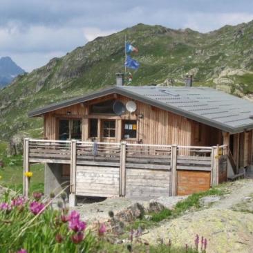
This hike is a little bit longer from the others, but it is not difficult. You can reach the beautifull site called ?les 3 lacs? (the 3 lakes) at the foot of the Etendard glacier.
Start Col de la Croix de Fer, follow signs for « Refuge de l'Etendard ».
Lengh : 5h Ramp: 366m to get to the refuge (catering).
Opening period
From 01/05 to 30/11.
Depends on the snow.
Ask the Tourist Office for more information.
Tarifs
Hiking guide for sale at the Tourist Office : 5€
Cartoguide : 7€
Pack of hiking guides and maps of the Massif Arvan Villard: 10€
Services
Activities
See also